Inspired by re-reading Kitty Hauser's fabulously otherwordly book, Bloody Old Britain: O.G.S. Crawford and the Archaeology of Modern Life, I started to googlemap the Middlefield Lane estate from the air. This is the field I used to play in - a former cornfield back in the day but now marked by ad-hoc 'desire' lines created mostly after my time there:

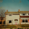
My house is to the right of that mid left-hand side shadowy gap (just above the reference to someone's mobile disco business ... ). When I was a child, there was a large electricity pole and two large sewer manholes near the centre of the field that slowly disappeared over time. There doesn't seem to be any trace of them on this photo but I'm going to look for them next week when I'm on the estate - notes on that to follow ...

My house is to the right of that mid left-hand side shadowy gap (just above the reference to someone's mobile disco business ... ). When I was a child, there was a large electricity pole and two large sewer manholes near the centre of the field that slowly disappeared over time. There doesn't seem to be any trace of them on this photo but I'm going to look for them next week when I'm on the estate - notes on that to follow ...
Comments
Post a Comment