'... it is only a short step of the imagination to envisage the onetime fields being themselves still there. with their grass and buttercups and even the footprints of cows, merely hidden beneath modern concrete and asphalt - as if you had simply to lift up a paving stone in order to reveal it.'
(Gillian Tindall, The Fields Beneath, 1977, p. 14)

I've noted before how the Middlefield Lane estate was built on the edge of Gainsborough. That was the way back then - slum clearance and dispersal out onto new estates on the 'distant rims' of towns. The planning of these estates often mirrored the 'prairies' of the open countryside they were set against and, as a consequence, they were very much despised by architectural critics like JM Richards and Gordon Cullen, and by the sociologists of the time, most notably Willmott and Young, who negatively pitted what they saw as the lonely, social fragmentation of the new estates against the supposedly warm and tightly-knit slum housing communities. It is still sad to note that those who were at the centre of trying to forge a progressive and socially democratic Welfare State culture ended up providing the central arguments for the future 'failure' of the post-war council estate. More recent studies however, such as Mark Clapson's Invincible Green Suburbs, Brave New Towns: Social Change and Urban Dispersal in Post-war England (1998) have attempted to counter this by arguing for the adaptable and essentially (whether we like it or not) suburban mind-set of those who moved from the slums: newly-weds like my Mum and Dad clearly understood that moving onto a new council estate meant both a move ‘up’ and a move 'away' - a chance for them to put some distance both between themselves and the sometimes over-close bosom of the extended family and, most importantly, the shameful decrepitude of the housing they were leaving behind.
The children of the time weren't complaining either. From this child's point of view at least, I had the best of every world possible at Middlefield - excitingly new, open and safe pedestrianised spaces on the estate, a shopping precinct to kick around, and open countryside that was just a few yards away at the end of our front garden path.
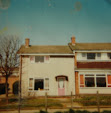
The photo above shows the view we had from our living room in 1966: a single arable field that gave me and my friends the annual thrill of seeing a combine harvester rumble past our living room windows, throwing up noise, dust, and tiny, breath-taking bits of corn as it went by.
The field always appeared to us like a very solitary field, untouchable even as all the building happened around it. It was bounded on one side by Heapham Road (a lane really back then, which went out into the wider countryside beyond), and by a fenced-off piece of scrubland on the other which was later transformed into a playing field. At the far end of the field was a long hedgerow and a ditch that was deep and always dried up. The field can be seen below, in the top right-hand corner of this 1972 aerial photo of the estate and just above the playing field where a few figures can be seen dotted around watching a pub team football match. My house was one of those directly opposite the field near the bend in the path that ran all the way along Dunstall Walk:

The earlier, pre-estate, extent of the field can be seen here in a detail from a 1951 O.S. map of Gainsborough, roughly where the 'UD &' is:


But a section of that field - the one opposite my house on Dunstall Walk - remained after the estate had been built. It was cultivated up until the early 1970s when a new by-pass cut through the far end of it. After then, it quickly transformed itself into waste ground: thistles, bracken, and shattered chunks of corroded reinforced concrete seemed to appear from nowhere, along with old bike frames and the innards of armchairs. But the field has persisted. Industrial units overshadow it today but it has never been built upon - this is how it looked in February a couple of years ago, indicative perhaps not of the Middlefield before Middlefield, but prescient rather of a Middlefield after Middlefield:

Interesting - who owns the field concerned, do you know? Must be on the land registry. Assume it became no longer worth cultivating for some reason?
ReplyDeleteDan