
These signs have been on the Middlefield Lane estate since its inception, and so they are forty-five years old at least. Some have weathered better than others:

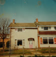
This planning of this estate was based to some extent on the 'Radburn' principle gleaned from an experimental 'New Deal' settlement that was developed in Radburn, New Jersey. This involved the fundamental separation of the car and the pedestrian, where cars gained access to the houses only via culs-de-sac roads that were situated 'round the back' of the short terraces of the houses themselves. The other side of these houses - 'the front' as we called it - had the main living area (the 'living room' to us, and NOT a 'lounge') which looked out onto an individual although unfenced or hedged 'private' expanse of lawn which led onto a public green space and a network of pavements, or 'Walks' that connected Dunstall Walk to Aisby Walk and so on.
I hesitate to take Alison Ravetz to task again, but she notes how 'it was difficult to distinguish the backs from the fronts of houses: in a conventional sense they had neither'. In fact it was easy - the 'front' led to a garden; the 'back' to the road - and no different surely (albeit with the situations reversed somewhat) from any number of terraced houses.
'Signs with arrows pointing to runs of odds and evens were provided ... Visitors, even residents themselves had difficulty locating addresses.' Hmmm ... odds on one side, evens on the other, except with an expanse of grass separating the two rows instead of a road? Again, not difficult to grasp, although not exactly conventional either, but wasn't that the point at that time? So what was there not to like (apart from those other signs forbidding kids to play ball games on these 'greens', but that is another story).
Hello Ian, I'm just rereading Alison Ravetz and agree about 'odds' and 'evens'. Though one place that - to the uninitiated - does have a baffling house numbering system is Cumbernauld. Then again, I expect it makes perfect sense to those that live there.
ReplyDeleteHere is a link to an estate sign I particularly like. I wonder what is underneath the addition of 'Pickering' .
http://www.flickr.com/photos/conservingthetwentiethcentury/6211248586/in/photostream/
Hi Hannah. Yes, it's not hard really - I'm sure the residents did know where they lived! I love your Hallfield sign photo - this is Tecton/Lasdun stuff isn't it? Would 'Pickering' (and 'Taunton') be later blocks (though surely they would have painted the names directly onto the sign instead of on those little inserts??). Maybe any original name under PIckering was of some regional town that fell out of favour in some way? The English provincialism at play here (good old English market town names) is typical of the time, but nice.
DeleteYes - Hallfield is Denys Lasdun and Lindsay Drake, a lot of it is set below surrounding street level and has a very enclosed, tranquil feel to it. From what I remember it dates from the early '50s. The estate was listed Grade II last year and is a mix of council and private ownership. I wonder how the Tecton factor and listed status will impact its desirability in the future...anyway I digress. I like to think that underneath Pickering is a disowned provincial market town.
ReplyDeleteReally enjoying your photographs!
Thanks Hannah - what a bunch of scraggy looking Herberts those kids were!
ReplyDeleteI do wonder what is 'underneath Pickering' - it's precisely those little micro bits of research, for instance the naming of blocks, roads and so on, and why they might change, that really need to be done by someone.